Showing posts with label complete streets. Show all posts

Monday, September 26, 2011

Masonic Avenue Redesign Fading As A City Priority


Bryan Goebel, editor of Streetsblog, and Michael Helquist

Image: SF Planning Department's City Design Group

On Bike to Work Day last May, Mayor Ed Lee told Streetsblog that he would look into speeding up funding for a sorely needed redesign of Masonic Avenue, one of San Francisco's most notorious arterial streets. The project seemed to be a priority for him, especially in the wake of two high-profile collisions that took the lives of Nils Yannick Linke and James Hudson.

“It’s very deserving of attention, particularly when it comes to pedestrian safety," Lee told Streetsblog on May 12.

“It’s time we take back Masonic Boulevard,” Supervisor Ross Mirkarimi proclaimed that same day at the Bike to Work press conference on the steps of City Hall. "It’s time that we actually step up the city’s game in making sure that Masonic is safe for bicyclists and pedestrians."

Now, nearly four months after the Masonic redesign was approved at an SFMTA engineering hearing, the plan is plodding its way through the vast city bureaucracy, its funding is uncertain and it is in danger of winding up on the shelf like so many other good projects unless City Hall puts some political muscle behind it.

The project hit a snag recently when the SFMTA was denied a $700,000 grant from Caltrans to pay for the design costs. A $41,000 request to complete an environmental impact report (EIR) is expected to be approved by the San Francisco County Transportation Authority soon. But a funding source for the biggest chunk, $18 million for construction, has still not been identified.

"The SFMTA is working with the Department of Public Works to refine the design cost estimate, and will apply to another funding source for design funds. A funding request made for construction funds is still pending. Meanwhile, other construction funding sources are being evaluated," said SFMTA spokesperson Paul Rose.

That doesn't sound particularly hopeful.

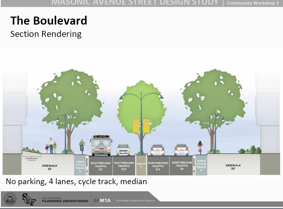
Advocates who have been pushing for a safer Masonic for more than seven years now have widespread neighborhood support for the redesign, which would dramatically re-engineer the street, adding a landscaped median, bus bulbs, a 6-foot wide raised cycletrack and other amenities to benefit pedestrians, bicyclists and transit riders.

Just a few years ago a safer, more livable Masonic was a project that pedestrian, transit, and bicycling advocates – along with city officials -- wanted to see implemented, but few thought possible. At first Masonic was part of the citywide bike plan that the SFMTA is now implementing, but the vital north-south corridor was dropped from the proposal, partly because it seemed unlikely to get broad public support. Yet nearby residents have surprised city officials with significant backing for a transformed street.

As early as 2008 more than 500 Masonic Avenue neighbors petitioned the city for a traffic corridor that worked better for all users. They ranked a dozen priorities to increase safety, traffic flow and improve the appearance of the street. The grass-roots group Fix Masonic rallied neighborhood associations, parents of kids at nearby schools, and district supervisors to support the plan. Together with the San Francisco Bicycle Coalition, Walk SF, and other advocacy groups, Fix Masonic helped secure funding for a feasibility and design study. By June of 2010 the SFMTA started a series of three community meetings to get public input and support for a revitalized Masonic, employing many of the traffic calming strategies proposed two years earlier. By October of last year, Masonic project manager Javad Mirabdal described the Masonic design as a “once in a lifetime” opportunity.

Although some westside residents preferred a less ambitious version for a changed corridor, the majority who participated in SFMTA and neighborhood association surveys preferred the Complete Streets option known as the Boulevard.

If implemented, the Masonic proposal could transform city neighborhoods, ensure a safer, more attractive means of transportation for all users, improve environmental impacts along the corridor, and boost property values and city revenue. The re-design of Masonic could reflect a determination by the city to step up to a higher level of livability in San Francisco.

It's time for Mayor Lee, and others at City Hall, to put their words into action, and for new Director Ed Reiskin to use the visionary and political skills that got him the job at the SFMTA to ensure that the Masonic Avenue redesign gets implemented soon instead of it getting mired in city bureaucracy.

Monday, November 22, 2010

Majority in SFMTA Masonic Avenue Survey Favors Boulevard Design


Boulevard design "is going to be a major improvement" for Masonic

The San Francisco Municipal Transportation Agency (SFMTA) announced that a majority of Masonic area residents favor the more complete Boulevard street design for the corridor. The package of traffic calming measures in the plan is expected to make Masonic Avenue safer for all road users and improve the visual appearance of a ten block stretch from Oak to Geary streets. Implementation of the Boulevard design awaits a final report due by the end of the year, followed by an approval process and a search for funding. Actual on-site construction is unlikely to begin for at least two years. BIKE NOPA presented details of the Boulevard option in a previous story. Masonic Avenue residents who attended a September 30 community meeting took the survey to give their preferences between two design options.

Javad Mirabdal, SFMTA Director for the Masonic Traffic Calming Project, told members of the North of the Panhandle Neighborhood Association (NOPNA) on November 18th that survey results indicated a solid preference* (see note below) for the more ambitious and more complete street design. "This is the better option," Mirabdal said. "It's going to be a major improvement and it will re-shape Masonic Avenue, creating a better feeling for driving and walking."

More than 50 NOPNA members attended the bi-monthly meeting; only two expressed concerns about the Masonic project. They cited the proposed removal of parking, the installation of a bike lane "on a busy street," and the extent of outreach leading to the community meeting where the survey was conducted. Mirabdal replied that to make Masonic safer, changes have to be undertaken and "something has to give" to allow space for the center median, the Muni bus bulb-outs, and a separated bike lane. He noted that in a SFMTA daytime parking study, 60% of the parking on Masonic was for less than two hours. He believes these short-term users are students from the nearby USF campus and not Masonic residents. "Less than 20% park more than four hours." He added that the Boulevard project will also create 50-80 new parking spaces to partially mitigate the loss of Masonic parking.

Mirabdal emphasized that the traffic calming package for Masonic "is not a bike project." During other public meetings he has added that Masonic is the only direct north-south route in the area for bicyclists, just as it is for motorists. Regarding the adequacy of community outreach, Mirabdal described the door-to-door distribution of meeting notices prior to the first two Masonic community meetings and a mass mailing of 1400 notices for the final meeting. The announcements included information for how to contact Mirabdal directly.

Masonic Avenue and NOPA residents have, in fact, received a continuous stream of information about the Masonic project in addition to what the SFMTA distributed. Jarie Bolander, NOPNA president, confirmed that notices of the Masonic meetings and project updates have been included in several previous association newsletters that are distributed to 5000 individuals. The meetings were also announced in email blasts to 800 members and other interested parties, and speakers have regularly discussed the Masonic project at NOPNA meetings. Neighborhood blogs and city-wide media have also covered the traffic calming proposals.

In addition to NOPNA, Mirabdal said he has talked with other neighborhood groups in the Masonic Area, including the Ewing Terrace Neighborhood Association, the University Terrace Neighborhood Association, the San Francisco Day School, and Fix Masonic.

The SFMTA expects to release a full report on the survey findings within the next two weeks.

For detailed project information: www.sfmta.com/masonic
Contact project manager, Javad Mirabdal: javad.mirabdal@sfmta.com
(415) 701-4421

For previous stories in the A Better Masonic series, check here.

* November 3o note: Javad Mirabdal requested a change in my report of his description of the degree of support for the Boulevard plan. He believes his statements indicated to the NOPNA audience that there was a "preference" rather than a "solid preference" for the proposal. Today's post reveals the actual data which indicate that 76% of survey respondents "strongly liked" or "liked" the Boulevard option while 64% favored the Gateway alternative.

Tuesday, May 4, 2010

New Divisadero With Inconsistent Crosswalk Design: Does SF Need "Great Crosswalks" Standards?


When motorists intrude into crosswalk: Divisadero and Fell Streets

BIKE NOPA note: Reader Jeff Gibson has conducted an impressive analysis of the new crosswalk designs along the Divisadero corridor. He focused on the pedestrian "refuges" or islands meant to give individuals a safe haven in the middle of wide streets. He is especially concerned that crosswalks like the east-west crossing at Divisadero and Fell actually remove full crossing space from pedestrians and that walkers often have to scramble around vehicles to walk through the designated passage. Individuals using wheelchairs or who have difficulty with curbs might find this situation more hazardous than before. Jeff agreed to share his review with BIKE NOPA readers. The descriptions and photos that follow are from his email message.

*****

I've photographed each crosswalk on Divisadero from Haight to Geary. I can't discern the guidelines under which these crosswalks were designed. There are a variety of configurations so it's obvious no single standard was applied -- not a bad thing necessarily but the logic for some of these designs escapes me. Below are a series of photos with my comments.

photo #1: looking East across Divisadero at Fell, from the SW corner

This prompted my initial query to Kris Opbroek @ DPW (Great Streets Program manager for the Divisadero improvements). I asked why the pedestrian pass-thru at the median was less than half the width of the crosswalk. Her response was that this was a safety feature to protect peds from left turning traffic (from Fell onto southbound Divisadero).

*****
photo #2: one block South, looking West across Divisadero at Oak from the NE corner

Here we have the exact same situation as at the Fell / Divisadero intersection: a one way street with cars in the left lane able to turn left onto Divisadero. Yet this crosswalk has no thumbnail and peds have the full width of the crosswalk from curb to curb. Why the inconsistency?

*****
photo #3: Divisadero at Oak (same intersection as #2), looking East from the SW corner

There is a thumbnail here where one wouldn't expect it, at least in the context of safety issues expressed by Kris Opbroek. Traffic on Oak is one way heading East, so there is no possibility of left turning traffic from Oak onto southbound Divisidero (the only scenario in which a thumbnail would come into play). Was this thumbnail supposed to be placed in the north crosswalk at this same intersection? (see photo # 2).

*****
photo #4: Again one block further South, looking East across Divisadero @ Page, from the SW corner
Here we have what I call a "floating" thumbnail. Is there some sort of design criteria that says a pedestrian pass-through must be no wider than 5 or 6 feet? (I actually did not measure, but they all looked to be the same width no matter the placement / configuration). Why could this thumbnail not be placed at the left margin of the crosswalk? Indeed, if these thumbnails are supposed to be a barrier against car traffic I don't see the wisdom of having half the available crosswalk space between the thumbnail and moving traffic.

*****
photo #5: looking East across Divisadero at Turk, from the SW corner

Here the thumbnail extends a bit outside of where the left crosswalk line will be painted, but the median somehow gets pulled to the left to extend into the pass-through. Why? As I said before, it seems the designers operated under the idea that pass-throughs can only be X number of feet wide and not an inch more. Another example of this can also be seen in photo #3. Very curious.

The examples above represent only a few of the intersections from Haight to Geary. Most to me have design quirks that have me wondering what the planners were thinking. Thumbnails, for example, appear in a variety of positions in various crosswalks, and the crosswalks at Fulton and O'Farrell are narrower than the rest. Given that every square inch of the final design was thoroughly considered, I wonder why the crosswalks turned out the way they did. There are of course far more egregious examples of poor pedestrian design throughout the city, but with the inclusion of Great Streets principles in this particular project, I would have expected better. Perhaps we need to ensure that "Great Crosswalks" criteria are integral parts of Great Streets.